
Superior MontanaListing Type: National Forest Trail |
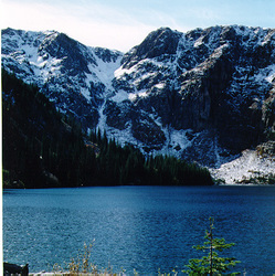 |
St. Regis Lakes Trail (267) is an all season area with splendid views of alpine country and flora. If cross-country skiing check with the Forest Service; or Friday-Sunday, the Avalanche Advisory 1-800-281-1030; or the Lookout Pass Ski Area. Avalanche conditions change so rapidly that you need to be your own best resource for snow conditions and safe skiing. The St. Regis Basin has a high occurrence of avalanches and can be very dangerous at times.
Length: 2.8 miles.Trail Begins: County road near old Mullan road.Trail Ends: Lower St Regis Lake
Area Map: Lolo Forest Visitors Map .USGS Map1: Lookout Pass, Montana – Idaho.Township 20N; Range 32W; Section 32
Directions: From I-90, take the Lookout Pas Exit at the top of the pass. Go south on Road 7896 on the south side of the interstate. Proceed 1 mile where the road begins to loop. Take the first road to the right and cross the old railroad grade. The road is in poor shape beyond this point. You may have to cross the creek on foot to the trailhead.
St. Regis Lakes Trail
Lolo National Forest, Superior, MT 59872
Activities
Services
|