Site Information
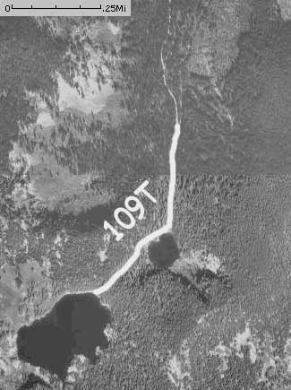
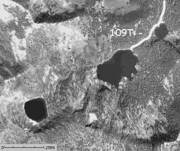
Oregon Lakes Trail-USFS Trail No_ 109
 Classification: Trail
Location: Forest road #320
Latitude: 47.0619°
Longitude: -115.0850°
Elevation: 5365 ft.
Length: 0.7Mi
End Location: Middle Oregon Lakes
End Latitude: 47.0555°
Longitude: -115.0903°
End Elevation: 5945 ft.
Area: Superior South
Usage: Light to Medium
Difficulty: Easy to Moderate
Legal Description: Township 15N; Range 28W; Section 13
Directions:
From Superior get on the south side frontage road to Cedar Creek Road. Go 20.4 miles to Oregon lakes turn off at Road #18688. Turn left and the parking area is within a half a mile.
Narrative:
To get to these lake you make a steep but short hike to the lower lake. Good campsites at the trailhead and lake. The trail from the lower lake to the middle lake isn't as steep. The lakes sit in cirque basins with great views and fair fishing for Eastern Brook Trout.
Access: Hiking
Facilities: Fishing, Hiking
Connections: Oregon Lakes
Trail Profile:
|
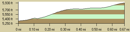
Photo:
|
The 7.5 minute series USGS topographic maps for that area
| Torino Peak | Wilson Gulch | Superior |
| Sherlock Peak |
Illinois Peak SW | Landowner Mountain |
| ? | Hoodoo Pass | Straight Peak |
Switch to TerraServer - Topo Map
Switch to TerraServer - Aerial Photo(If Avail.)
Switch to Maptech MapServer
Switch to TopoZone MapServer
Switch to TopoWest Quad MapServer