Site Information
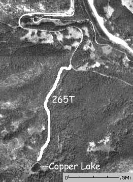
Copper Lake Trail-USFS Trail No_ 265
 Classification: Trail
Location: County road, near Mullan road
Latitude: 47.4387°
Longitude: -115.6963°
Length: 1.6Mi
End Location: Copper Lake
End Latitude: 47.4236°
Longitude: -115.7038°
Area: West End South
Legal Description: Township 19N; Range 32W; Section 5
Directions:
From I-90 take the Lookout Pass Exit 0, Go south on Road 7896 for 2 miles to the trailhead.
Narrative:
An enjoyable hike to a beautiful mountain lake.
The 7.5 minute series USGS topographic maps for that area
| ? | ? | Driveway Peak |
| Mullan |
NW Lookout Pass | Saltese |
| ? | ? | Adair |
Switch to TerraServer - Topo Map
Switch to TerraServer - Aerial Photo(If Avail.)
Switch to Maptech MapServer
Switch to TopoZone MapServer
Switch to TopoWest Quad MapServer